TMB Trail Conditions 12th June 2025
12/06/2025
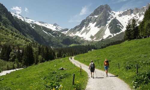
It is hard to believe that snow persists above 2200m when you are in the valley bottom, which is lush and green. However the situation is different when you are in the high mountains and snow does persist in some areas on the high ground making passage slow, difficult and potentially dangerous. We have continued to monitor the conditions over the past few weeks and this week been out on the TMB to see how this will affect the start of season 2025. The good news there is much less snow than last year!
Over the past few weeks, we have seen a large amount of rain and this week much warmer temperatures which has made things a lot easier.
The main areas affected by snow are:
Chamonix to Les Houches via the Col du Brevent
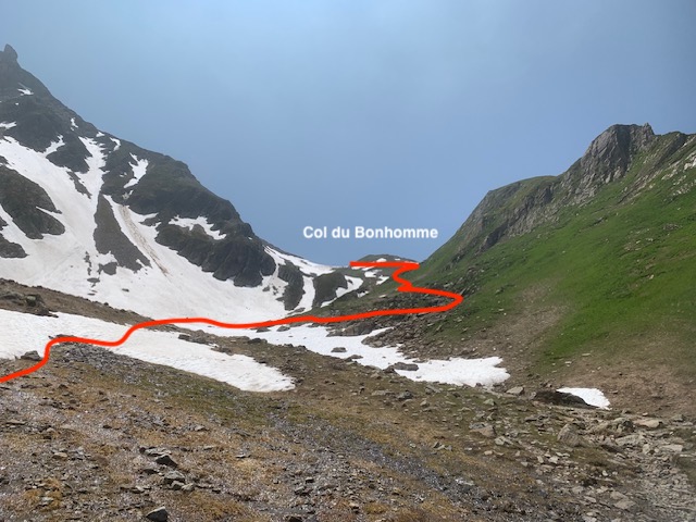
Contamines to Chapieux & Ville des Glaciers via the Col du Bonhomme (2443m) & the Col de la Croix Bonhomme (2483m) & Col des Fours (2665m) if going to Ville des Glaciers.
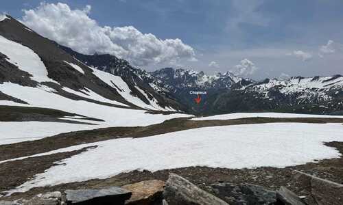
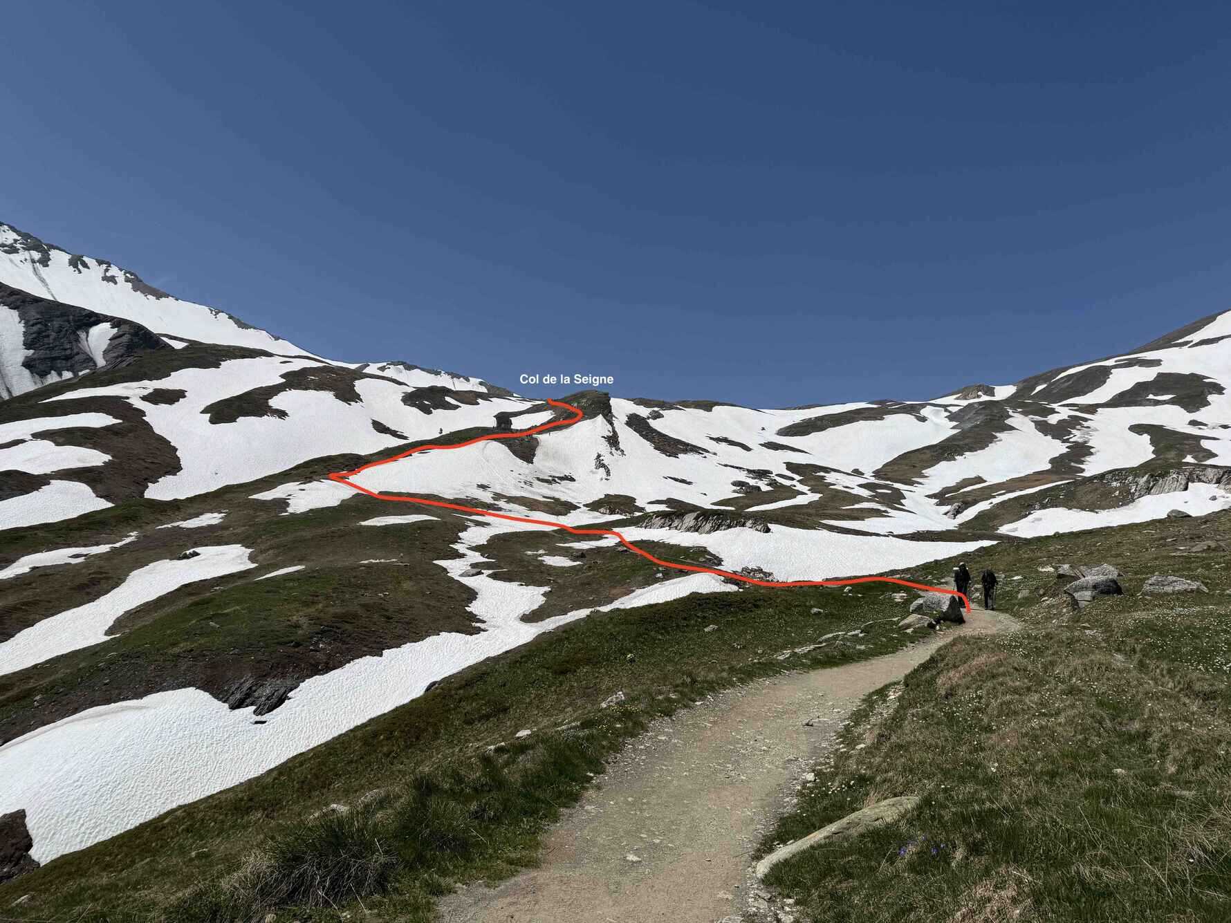
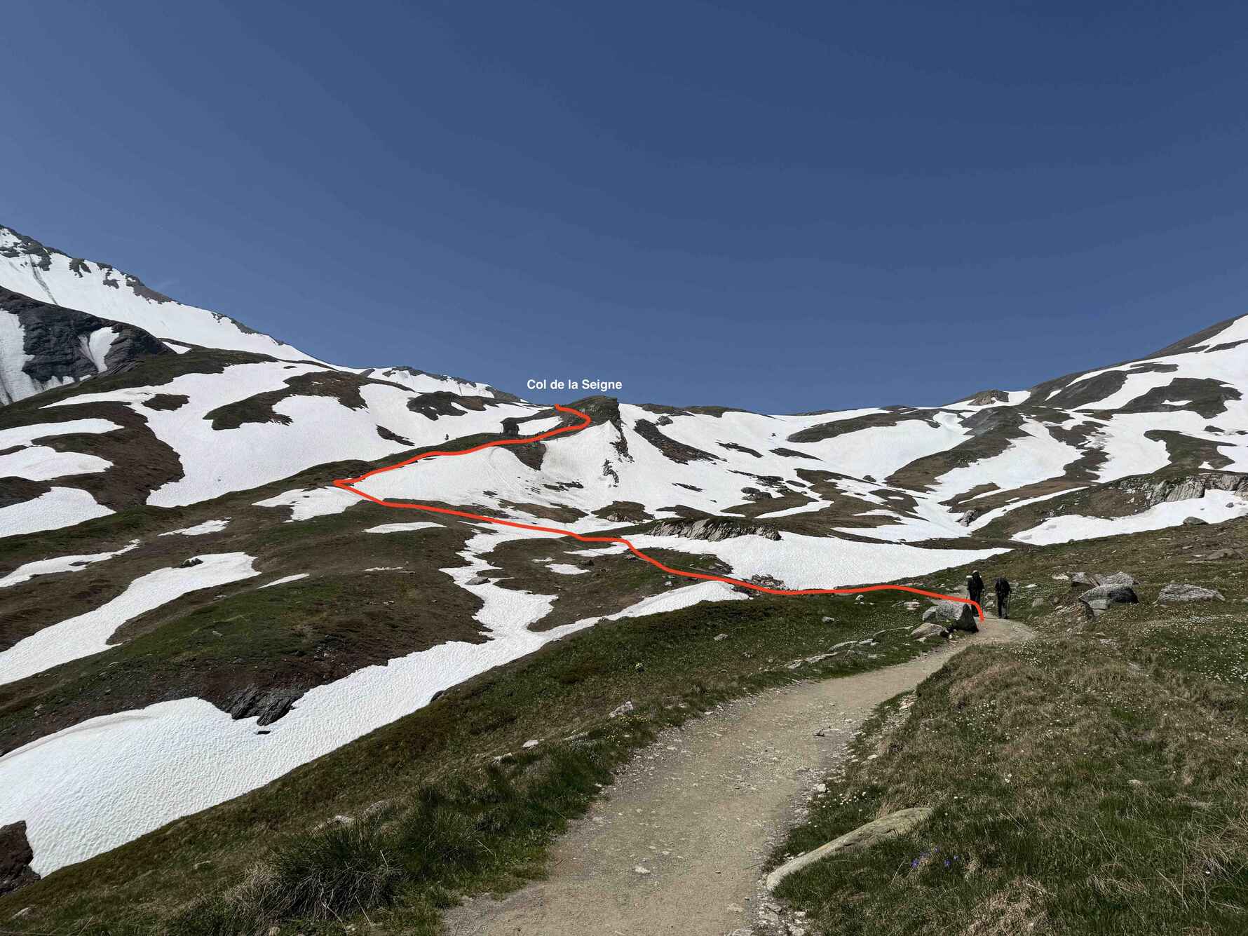
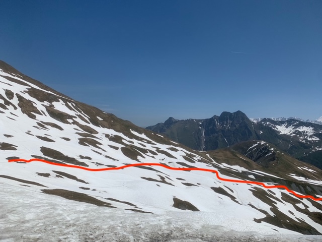
Chapieux & Ville des Glaciers to Courmayeur via the Col de Seigne (2516m) & Vielle d’Arp and the Mont Fauvre spur.
Val Ferret to La Fouly via the Grand Col Ferret (2537m)
Champex to Trient via the Fenetre d’Arpette (2665m)
For your own safety and comfort please take notice of our advice where the route is not advisable or micro-spikes are advised to aid safe passage.
The itinerary in brief
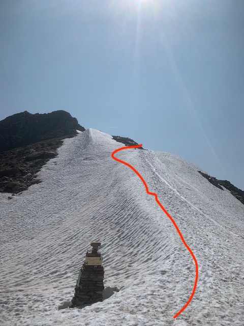
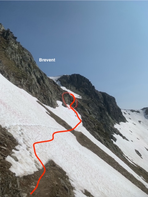
Day 1: Chamonix to Les Houches, The Brevent Planpraz cable car reopens on June 14th. After departure from Planpraz the trail remains snow free until arrival at the Col du Brevent 2368m, from this point the snow remains relatively consistent to the top of Le Brevent 2526m.
Some parts of the trail are buried however there is an obvious trace through snow to follow. Regular appearance of the trail can be identified however in bad visibility concentration is needed to follow the correct passage.
There are 2 short sections of snow to be crossed immediately before the ladders, currently this passage needs extra care as a slip could involve an injury or worse.
Walking poles and micro-spikes are essential even if only for this short section.
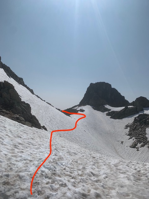
After climbing the ladders, the trail still has snow but is easier to pass through to the summit of Le Brevent.
From summit station down to Refuge Bellachat 2152m Snow remains but is easily passable.
If in doubt take the cable car to the top of Brevent to avoid this section.
Day 2: Les Houches to Contamines: The route over the Col du Tricot has no snow. Route via Bionnassay & Champel no problems.
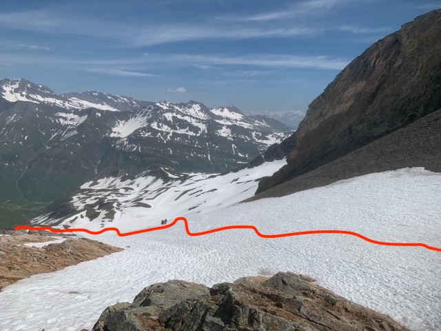
Day 3: Contamines to Chapieux or Ville des Glaciers: The snow is melting fast on this section of the TMB. Some patches can be encountered before the arrival of the 1st Col du Bonhomme but the trail remains always visible. From the Col du Bonhomme to the 2nd Col of the Croix du Col Bonhomme sections of snow are regular, attention is needed, however a big track is in place for ease of crossing. Micro-spikes are still useful if extra security is needed. From the Croix du Col Bonhomme snow remains on the final descent to Les Chapieux stopping around 2200m, after this section, the trail is prone to becoming very Muddy.
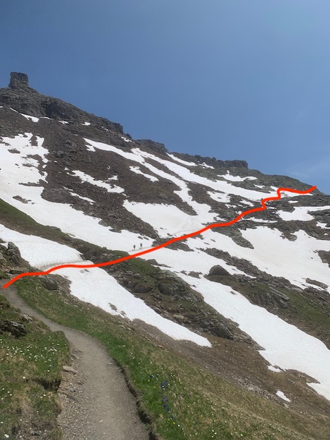
Variant via the Col des Fours: There are hikers already passing over the higher variant of the Col des Fours 2665m, however; in early season we do not recommend this route due to the volume of snow and the steep terrain. This year there is still a lot of snow in this area. Micro-spikes and poles are essential as the terrain is much more complicated to descend. Extra attention is needed, not recommended in bad visibility.
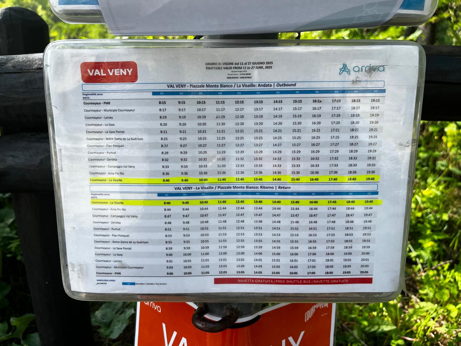
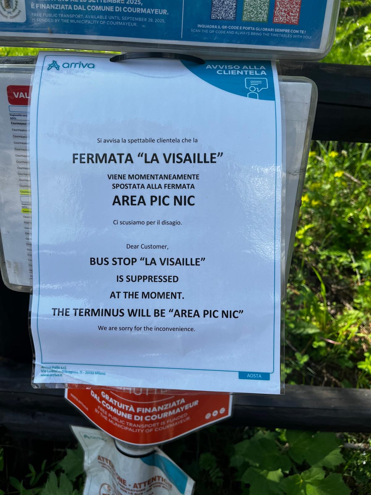
Day 4: Chapieux or Ville des Glaciers to Courmayeur: This day is surprisingly snow free, there is snow around the Col de la Seigne but it is avoidable. We did not recce the section between Lac Combal via the Mont Fauvre spur to Courmayeur so we cannot comment on this section. You can descend from Lac Combal to La Visaille and walk or take the navette into Courmayeur. The bus is running but isn’t going as far as La Visialle at the moment. Continue down the road and take the bus lower down.
Day 5: Courmayeur to Val Ferret (Bonatti, Lavachey, Chalet Val Ferret): Ok if a lower route is taken as described in the route card.
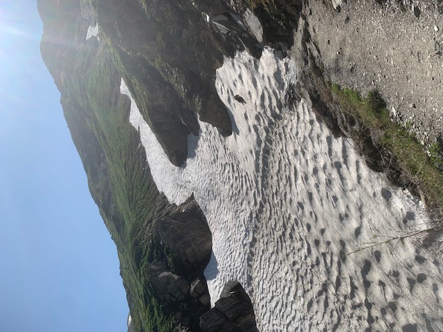
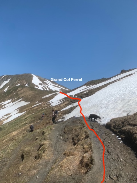
Day 6: Val Ferret to La Fouly: The Trail up to the Grand Col Ferret from the valley is mostly snow free. There are a few snow filled gullies that need to be crossed below the Refuge Elena, that require solid, slow, careful movement but these are short sections.
As the snow melts these will become more difficult. From the Refuge Elena (opens on 15th June) to the top of the Grand Col Ferret any sections of snow can easily be avoided. The descent from the col into Switzerland still has a lot of snow cover but no real hazards.
Just watch out for holes in snow, lots of mud and the small section of path that narrows/ exposed around 2300m before the La Peule refuge.
Day 7: La Fouly to Champex: No problems, route as normal.
Day 8: Champex to Trient: The Bovine route is free of snow and is fine.
Do not attempt the variant via Fenetre d’Arpette in early season, as with the Col des Fours the route is steep on both sides of the col and when banked out with snow, a slip of fall here could be serious or fatal.
Day 9: Trient to Argentiere: Take the route direct from Trient to the Col du Blame, some snow patches but ok.
Day 10: Argentiere to Chamonix: The Aiguille Rouges nature reserve still has snow; therefore, we advise to remain on the lower balcony to Flegere and do not ascend to Lac Cheserys and Lac Blanc for the next week until snow clears, the route from Flegere to Brevent has no problems.
Essential kit:
· All kit outlined on our kit list not forgetting good waterproof boots, gloves, warm hat, warm layers, waterproof outer layers, sun cream & sunglasses to protect against snow glare.
· Micro-spikes & walking poles x 2 per person to aid balance.
Important to remember
Walking on snow can be very tiring and time consuming, you will need a good level of fitness in order to be able to cope with this additional challenge. You will also need to allow more time each day to get to your destination.
Snow and bad weather also make navigation difficult as you cannot see the designated path and route markets and signage will be covered with snow. Good navigational skills are essential, the ability to read a map, use a compass and altimeter are a pre-requisite of this self-guided trek.
Due to the current condition’s information given on the route cards may be inappropriate. You need good mountain sense and the ability to make your own decisions, from the information given and your own experience it is your responsibility to select alternative routes.
Snow on high ground this can make the route difficult and dangerous in places. A great deal of care needs to be taken when moving on Neve (old snow), depending on the weather this can be frozen solid or slush and without crampons can be impossible to cross without slipping. It is essential that you make a risk assessment before crossing snow, look below and ask yourself if you slipped how far would you slide & fall? Could a slip or fall cause injury? If in doubt retreat back and descend.